


Latest Version
25.7.4-837
July 28, 2025
Waymarked Trails LTD
Maps & Navigation
Android
0
Free
com.waymarkedtrails.hiiker
Report a Problem
More About HiiKER: The Offline Hiking app
HiiKER is a comprehensive hiking application that provides access to over 100,000 verified trails worldwide, allowing users to discover, explore, and enjoy outdoor adventures. The app offers the ability to find nearby campsites, hotels, huts, stores, water sources, and other essential amenities, ensuring a well-planned hiking experience. Users can search for trails tailored to their preferences, and even download them for free to navigate offline, making it convenient for remote or GPS-challenged locations.
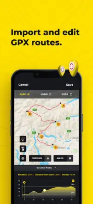
One of the core features of HiiKER is its trail planning and recording capabilities. Users can create custom routes using the route planner, which can be downloaded to their device for offline use. The app also enables users to record their hikes, capturing detailed activity data that can be shared on platforms like Strava, Garmin, or with the hiking community. Additionally, users can import and export GPX files, allowing flexibility when working with routes from other apps or devices. The app also supports the creation and editing of custom waypoints, useful for marking campsites, geocaches, or key checkpoints along the route.
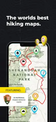
HiiAKER provides free offline maps, ensuring safety and convenience even in areas with no cell service. Users can access high-resolution map layers such as satellite, terrain, and various specialized maps from trusted sources including USGS, National Park Service, and Ordnance Survey UK. These maps can be used in conjunction with the app’s other features to enhance navigation accuracy. Moreover, users can download thousands of trail maps for free and export GPX files to synchronize with other GPS devices like Garmin or Suunto, providing seamless integration across multiple platforms.
For users seeking advanced features, HiiKER offers a PRO+ subscription starting at $4.99 per month or $49.99 annually. This tier provides additional tools such as distance measurement, stage-by-stage trail planning, and access to premium high-resolution maps from top map developers around the world. HiiKER also emphasizes data quality by partnering with official trail organizations, national parks, and trusted sources to ensure the trail information is current and accurate. Support services are available via email, and the platform encourages donations to the organizations maintaining and protecting the trails, ensuring ongoing access to reliable trail data and support.
Rate the App
User Reviews


Popular Apps