

Latest Version
July 07, 2025
MarineTraffic Applications
Maps & Navigation
Android
0
Free
com.marinetraffic.android
Report a Problem
More About MarineTraffic - Ship Tracking
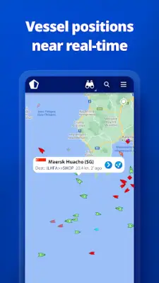
This application connects to the largest network of land-based AIS receivers, providing comprehensive coverage of major ports and shipping routes around the world. Users can view real-time vessel locations on an interactive map, search for ships, boats, and seaports, and discover vessels near their location. The platform reports position data for more than 300,000 vessels daily, ensuring up-to-date information for marine enthusiasts and professionals alike.
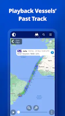
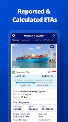
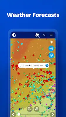
In addition to live vessel tracking, the app offers features such as live wind data and 48-hour wind forecasts displayed directly on the map. Users can utilize an animated playback option to review a vessel's historical track, which is useful for analyzing ship movements over time. The app also provides real-time port arrivals and departures across more than 4,000 ports and marinas, with current port conditions and estimated times of arrival for ships, making it a valuable tool for port operations and logistics planning.
Managing and customizing vessel information is simple with the "My Fleet" feature, allowing users to create and share a list of selected vessels across multiple devices and with MarineTraffic.com. The platform hosts an extensive library of over 4.5 million photos, including images of ships, harbors, and lighthouses, which can be useful for identification and visual reference. For staying beyond the range of land-based stations, satellite tracking with Access Plus offers vessel identification and tracking capabilities via satellite.
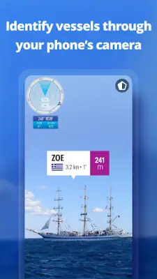
One of the app's innovative features is the Augmented Reality tool, which enables users to point their device's camera toward the horizon and instantly receive information about vessels in the vicinity, such as their names, flags, speed, and proximity. Premium subscribers gain access to advanced nautical charts, weather maps, density maps, and Satellite AIS data for more in-depth analysis. The app encourages users to verify coverage for their specific area before purchase to ensure the best experience and data accuracy.
Rate the App
User Reviews


Popular Apps