
Latest Version
1.3.1
February 20, 2025
Fishing Points d.o.o.
Maps & Navigation
Android
1
Free
app.huntingpoints.android
Report a Problem
More About Hunting Points: GPS Hunt Map
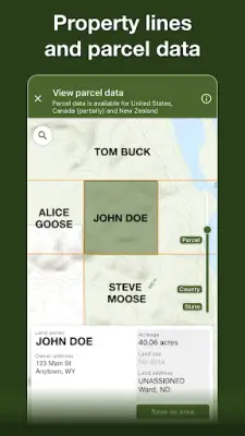
The application provides users with convenient access to land boundaries and property lines throughout the United States, while also offering information on land ownership, including maps that display owner names and addresses along with related parcel data and acreage details. In addition to comprehensive coverage of U.S. land properties, the app also extends its services to New Zealand and offers some functionality for users in Canada, ensuring a broad range of geographical support for outdoor enthusiasts.
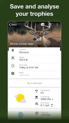
One of the standout features of the app is its trophy room, allowing users to meticulously document their hunting experiences by saving information about each catch, such as photos, weight, and species type. The app enhances the hunting experience by automatically including relevant weather data and solunar (sun and moon phase) information, ensuring that hunters have all the necessary details at their fingertips to reflect on their achievements in the field.
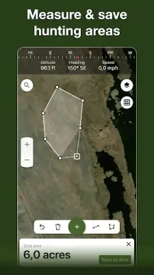
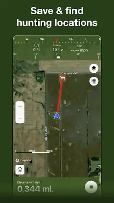
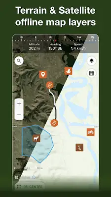
For navigation purposes, the application offers a variety of tools, such as saving locations, tracking routes, and measuring both distances and areas. Users can create detailed maps of their hunting terrain by drawing tracks, trails, and identifying hotspots. The app is designed to assist hunters in saving and locating their favorite hunting spots, utilizing GPS navigation to enhance their overall experience in the great outdoors.
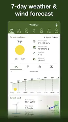
The application also includes a comprehensive weather section that provides current conditions as well as detailed forecasts, including hourly and 7-day predictions and severe weather alerts, which are crucial for planning hunting trips. Additionally, it offers insights into animal movement and feeding times, calculated based on solunar data, enhancing the likelihood of successful hunting outings. Users can further engage with the app by sharing their experiences, importing GPS files, and connecting with friends, making the app not just a tool for individual use but a community-focused platform for hunters.
Rate the App
User Reviews


Popular Apps