
Latest Version
7.8.0
June 09, 2025
ATLOGIS Geoinformatics GmbH & Co. KG
Maps & Navigation
Android
0
Free
com.atlogis.centralamerica.free
Report a Problem
More About Latin America Topo Maps
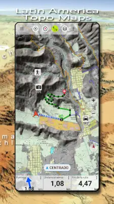
This navigation application allows users to select from a wide variety of map layers, including topographic maps, aerial images, nautical charts, and more, to effectively plan their outdoor trips. The app transforms Android devices such as phones or tablets into powerful offline GPS units, ideal for backcountry exploration. Users are encouraged to use popular map sources like OpenStreetMap, Google, or Bing for the most recent and accurate maps, but the app also supports importing maps from other sources such as GeoPDF, GeoTiff, and online map services like WMS or WMTS. This flexibility ensures that users can customize their map views according to their specific needs and regions of interest.
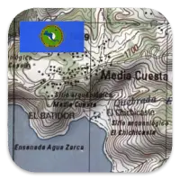
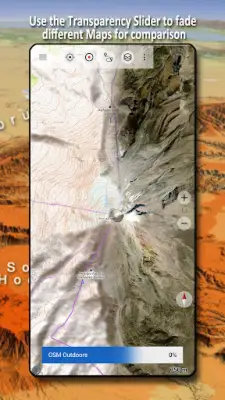
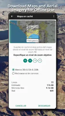
For regions like Latin America, the app offers detailed topographic map layers for countries such as Mexico, Brazil, Argentina, Paraguay, Peru, Bolivia, Chile, and others. These maps range from scales of 1:20,000 up to 1:250,000, with varying coverage percentages, providing detailed terrain information suitable for hiking, trekking, or exploration activities. On a global scale, the app includes base maps from popular providers like OpenStreetMap, Google Maps, Bing Maps, and Earth at Night, along with overlays such as hillshading, contour lines, and OpenSeaMap. Users can layer and adjust transparency to compare different map types seamlessly.
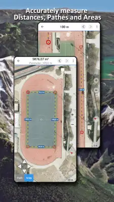
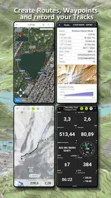
The app boasts numerous features tailored for outdoor navigation, including offline map downloads, route and waypoint creation, editing, and navigation. It supports various navigation modes such as point-to-point routing, auto-routing based on activity profiles (walking, cycling, mountain biking), and track recording with detailed data like speed, elevation, and accuracy. Additional functionalities include measuring distances, importing and exporting GPS data in formats like GPX, KML, and KMZ, as well as advanced search options for places and points of interest. Customizable data fields such as speed, direction, and elevation allow users to personalize their navigation experience. Sharing capabilities via email or cloud services further enhance its usefulness for collaborative outdoor adventures.
Designed for a wide range of outdoor activities, the application is suitable for hiking, biking, camping, climbing, riding, skiing, hunting, snowmobiling, off-road driving, and search and rescue operations. Users can add custom waypoints using various coordinate formats like longitude/latitude, UTM, or MGRS with WGS84 datums. The app also enables importing, exporting, and sharing GPS tracks, waypoints, and routes in common formats, facilitating easy data management and interoperability. For support or feature suggestions, users are encouraged to contact the developer via email, ensuring continuous improvements and user satisfaction in their outdoor navigation experience.
Rate the App
User Reviews


Popular Apps